Welcome

Welcome


loc300

Over Kellet Village

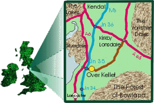
The village of Over Kellet lies on the B6254 just one kilometre from junction 35 of the M6 motorway. Its centre is an open and unique village green which includes both a cross roads and slip roads in the form of a diamond shape. In early Spring the Green is ablaze with daffodils planted by the pupils of the local Primary School.
The village boasts a pub (The Eagles Head), a village store and Post Office,the Parish Church of St Cuthbert's, a recently refurbished Village Hall, a C. of E. Endowed Primary School, and a War Memorial, all of which have been featured in the 'Best Kept Village of Lancashire' Competition which was first won in 1999. 

For a more detailed map of the hinterland visit Multimap

viewnrth

There are extensive views from most parts of the Village. The foreground is rural but embraces the narrow communications corridor taken up by the A6 trunk road and the M6 Motorway plus the West Coast Main Rail Line. The Lancaster Canal also passes close to the Village.

The background to this corridor includes Morecambe Bay to the west with the Lakeland Fells forming a backdrop all the way round to Shap. The limestone crags of Farleton Knott and Warton Crag take up the middle ground.


The Over Kellet View

Important! Please read below.

Issue No.144
NOW AVAILABLE

Apologies for the delay

PLEASE NOTE THAT ISSUE 144 IS THE FINAL VERSION WHICH WILL BE MADE AVAILABLE HERE, AS NO FURTHER UPDATES WILL BE UPLOADED TO OVERKELLET.ORG AFTER THE END OF JANUARY 2022.

IN FUTURE YOU WILL BE ABLE TO DOWNLOAD YOUR COPY OF THE OVER KELLET VIEW FROM THE OVER KELLET PARISH COUNCIL WEB SITE: https://overkelletpc.org/ 


You can get the Android App - NeoReader QR & Barcode Scanner from Google Play

Get it on Google Play


Sitemap
Print Version
Contact
Login


Over Kellet, Carnforth, Lancashire, United Kingdom
Last update:
31 January 2022